En
Menu
English
Arabic
Brazil
French
German
Italian
Russian
Simplified China
Traditional China
Spanish
Turkey
India
Vietnam
Japanese
Korean
About app
Contacts
En
English
Arabic
Brazil
French
German
Italian
Russian
Simplified China
Traditional China
Spanish
Turkey
India
Vietnam
Japanese
Korean
This section is not available yet
Home
Maps
South Korea
Yongdang-dong
Sections
Top places
Entertainment
Park
Attractions
Memorial
Monument
Museum
Business
Lodging
Shops
Supermarket
Health
Hospital
Food
Restaurant
Education
College
School
University
Transport
Gas station
Parking
Finance
Post
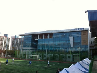
College
부산인력개발원
South Korea, GPS: 35.125916,129.10332
Gas station
Pekteu Gas Station
2.0
Bukhangdaegyo Gas Station
2.0
Hospital
Gana Hospital
1.0
가나병원 (Gana Hospital)
2.5
Memorial
강제동원추모탑
0.5
Monument
용비탑
2.5
Museum
일제강제동원역사관
남구 홍곡로320번길 100, Busan, Busan, South Korea, GPS: 35.125015,129.09286
국립일제강제동원역사관
0.5
Park
평화공원
2.5
park
2.0
Parking
상시검정장 지하주차장
2.5
Post
Yongdang Postal Agency
1.5
Dongmyeong University Post Office
1.5
Restaurant
Busan Fish Restaurant
2.0
Areum Fish Restaurant
2.0
School
동명정보공업고등학교
부산광역시 남구 용당동 500, Busan, Busan, 608080, South Korea, GPS: 35.12067,129.10216
Seokpo Girls Middle School
0.5
Supermarket
Chuksan Mart
1.5
Yongdang hyundai I Park
2.5
University
부경대학교 용당캠퍼스 셔틀버스
South Korea, GPS: 35.11618,129.09048
동명대학교
남구 (신선로 179번지), Busan, Korea, 608-711, South Korea, GPS: 35.122646,129.1022
Show on map
Show list
MAPS.ME
is always on hand
Download the apps and start expanding your horizons
Open Maps.me app
Use web version