En
Menu
English
Arabic
Brazil
French
German
Italian
Russian
Simplified China
Traditional China
Spanish
Turkey
India
Vietnam
Japanese
Korean
About app
Contacts
En
English
Arabic
Brazil
French
German
Italian
Russian
Simplified China
Traditional China
Spanish
Turkey
India
Vietnam
Japanese
Korean
This section is not available yet
Home
Maps
Indonesia
Kudus
Sections
Top places
Entertainment
Park
Attractions
Mosque
Business
Lodging
Hotel
Shops
Bookstore
Marketplace
Supermarket
Health
Hospital
Food
Education
School
Transport
Bus station
Gas station
Finance
Bookstore
Toko Buku Prima (kosong)
0.5
Bus station
terminal kudus
Indonesia, GPS: -6.8408813,110.81948
Gas station
Pom Bensin Dersalam
1.0
pom tanjung
1.5
Hospital
Rumah Sakit Mardi Rahayu
1.5
RS. MARDI RAHAYU Kudus
2.9
Jalan AKBP Agil Kusumadya (Jalan Grobogan - Demak), Kudus, Jawa Tengah 59301, Indonesia, GPS: -6.8297396,110.8312
Hotel
Hotel Salam Asri
Jalan Kudus - Pati, Jati, Jawa Tengah, Indonesia, GPS: -6.804237,110.86872
naga home stay
Indonesia, GPS: -6.810277,110.8287
Marketplace
Pasar bitingan
Jl. AgiL kusumadia, Jatirejo, Jawa Tengah, Indonesia, GPS: -6.8167486,110.83665
Mosque
mushola
2.0
Masjid
2.5
Park
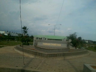
Taman Ganesha P2KH Kudus
Indonesia, GPS: -6.804549,110.825516
School
MI / MTs / MA NU Ibtidaul Falah
1.5
SDLB Purwosari Kudus
2.0
Supermarket
HYPERMART
2.5
Credit Cards
+
more
Pasar Swalayan ADA
3.6
Raya Kudus - Jepara KM 1 (Prambatan), Kudus, Jawa Tengah, Indonesia, GPS: -6.80402,110.82749
Credit Cards
+
more
Show on map
Show list
MAPS.ME
is always on hand
Download the apps and start expanding your horizons
Open Maps.me app
Use web version