En
Menu
English
Arabic
Brazil
French
German
Italian
Russian
Simplified China
Traditional China
Spanish
Turkey
India
Vietnam
Japanese
Korean
About app
Contacts
En
English
Arabic
Brazil
French
German
Italian
Russian
Simplified China
Traditional China
Spanish
Turkey
India
Vietnam
Japanese
Korean
This section is not available yet
Home
Maps
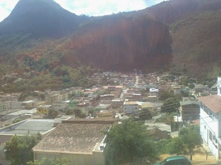
Brazil
Pancas, Espírito Santo
Sections
Top places
Entertainment
Park
Attractions
Church
Business
Lodging
Camping
Guesthouse
Shops
Health
Hospital
Food
Restaurant
Education
School
Transport
Bus station
Gas station
Finance
Bus station
Rodoviária De Pancas
Brazil, GPS: -19.222334,-40.851948
Camping
Sítio Cantinho do Céu, Camping
1.0
Camping Cantinho do Céu
0.5
Church
Igreja Luterana de São Bento
1.5
Igreja Luterana de Floresta
1.0
Gas station
Posto Pedra Agulha
2.5
Guesthouse
Pousada Ninho da Águia
Brazil, GPS: -19.22629,-40.84884
Hospital
Hospital e Maternidade de Pancas
1.0
Park
Praça João XXIII
Brazil, GPS: -19.223547,-40.850582
Restaurant
Bar do Tom
1.5
regional
Price
Menus
+
more
Cachoeira's Bar
1.0
regional
School
EUMEF Alfredo Loose
2.5
EUMEF São Lucas
2.5
Show on map
Show list
MAPS.ME
is always on hand
Download the apps and start expanding your horizons
Open Maps.me app
Use web version